V2ROADS' V2X Smart Core (V2SC) software effectively enables the opportunities provided by V2X technology. V2SC software is installed on vehicle on-board units (OBU) and significantly improves road safety, traffic efficiency, and additional options for autonomous driving.
Software for on-board units (OBU)
applications provided by V2X Smart Core:
CA messages (CAMs) make road users, equipped with ITS stations, aware of each other's environment: location of vehicles, speed and direction, condition of lighting equipment, etc.
Based on information received from CAM messages, safety applications will assess the risk of a collision and, where necessary, issue an alert to the driver of a vehicle equipped with an ITS station.
Based on information received from CAM messages, safety applications will assess the risk of a collision and, where necessary, issue an alert to the driver of a vehicle equipped with an ITS station.
Cooperative awareness basic service
(CA service)
DENM messages contain information about dangerous road situations and special traffic conditions e.g., roadworks, human presence on the road, stationary vehicles.
Based on the information received from DENM messages, safety applications will assess the risk of a collision and where necessary, issue an alert to the driver of a vehicle equipped with an ITS station.
Based on the information received from DENM messages, safety applications will assess the risk of a collision and where necessary, issue an alert to the driver of a vehicle equipped with an ITS station.
Decentralized environmental notification basic service
(DEN service)
The RLT service is an infrastructure service designed to transmit a road network map (RNM). The RNM includes traffic, parking spaces, pedestrian crossings, road intersections, traffic signs, etc.
In the RNM fragment example below, an area of road infrastructure describing the intersection of traffic lanes is shown
In the RNM fragment example below, an area of road infrastructure describing the intersection of traffic lanes is shown
Road and lane topology

The figure shows an RNM example. Each entrance to the intersection (blue lanes) has an exit lane (red lanes). RLT service allows drivers to identify the correspondence between the messages about the traffic lights phase (SPATEM) and the specific direction of traffic that is controlled by this traffic light (black lines).
(RLT service)
The TLM service is an infrastructure service designed to transmit messages in relation to the phasing of traffic lights (SPATEM).
The TLM service informs road users in real-time about: the traffic light operation mode, permitted manoeuvres, priority traffic directions at regulated and unregulated intersections, etc.
The TLM service informs road users in real-time about: the traffic light operation mode, permitted manoeuvres, priority traffic directions at regulated and unregulated intersections, etc.
Traffic light manoeuvre
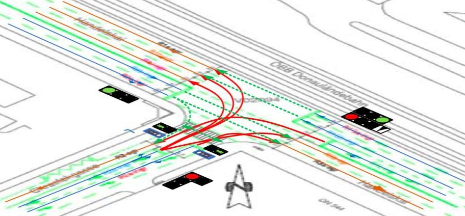
The figure above shows a TLM service example. The lines in the figure describing permitted (green dotted lanes) and prohibited (red lanes) manoeuvres are highlighted in a specific color, depending on the status of the traffic light signals.
(TLM)
GPC service is a service that provides real-time transmission of RTK (real-time kinematic) corrections improving positioning accuracy in GNSS equipment. The data used to make corrections is generated by roadside equipment and sent to on-board units. RTCMEM messages are used to transmit information.
GNSS position correction
(GPC service)
The IVI service is an infrastructure service designed to manage the creation, transmission, and reception of IVIM messages. IVIM messages contain information about mandatory and advisory road signs, such as situational speed warnings, roadworks, etc. IVIM messages provide information about physical road signs, such as static or variable road signs, as well as virtual signs.
Infrastructure to vehicle information
(IVI service)
The application provides the driver with information about dangerous situations arising whilst the vehicle is moving.
It supports the following scenarios:
It supports the following scenarios:
Road hazard signaling
(RHS application)
This scenario makes it possible to warn the driver about approaching roadworks hazards in time, through the vehicle's HMI (Human Machine Interface), so the driver can choose a suitable speed to exercise control of the vehicle and prevent possible collisions with workers/obstacles when entering the roadworks area.
Roadworks
This scenario is used on roads prohibited for pedestrians (highways, expressways, etc.) and warns drivers about their presence through the following channels:
1) automatically – when the vehicle automatically detects that a passenger has exited the vehicle:
2) in manual mode – when the alert is triggered by the passenger himself on leaving the vehicle.
A notification is displayed on the vehicle's HMI on approaching the event and the distance to the hazard. After the vehicle has passed the dangerous section of the road, the warning on the HMI is disabled.
Human presence on the road
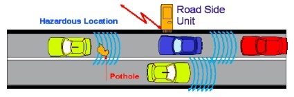
If the vehicle's trajectory intersects with a hazardous location (temporary or permanent), then the vehicle's HMI displays a notification as it approaches the location and the distance to it. After the threat of an emergency ceases, the warning on the HMI is disabled.
The implementation of this scenario allows drivers to respond on time to the threat of a potential emergency.
The implementation of this scenario allows drivers to respond on time to the threat of a potential emergency.
Hazardous location